| Property market | £286,975 for a semi-detached property | |
| Airport access | Closest airport is London Stansted (75.0 miles) | |
| Broadband | 45.6mbps average broadband speeds (average broadband for UK) | |
| Ethnic diversity | White: 96.3% residents (vs 81.7% England & Wales) Other: 3.7% residents (vs 18.3% England & Wales) | |
| Socio-economic status | Ranked 262 out of 573 in England & Wales for % of residents in higher managerial positions and 488 out of 573 for residents who are long-term unemployed (Broadland level) | |
| Community | Median age is 48.1 | Population of 7,378 | Happiness is Below Average for Norfolk, High for UK | |
| Crime | 1.0 burglaries per 1k people (Broadland) | |
| Commute (approx) | - Cambridge (116 mins) - Stratford (London) (148 mins) - London Liverpool Street (157 mins) - Manchester Piccadilly (322 mins) | |
| Quick links | Ask a question about Aylsham on the discussion board View more locations in Norfolk View nearby schools on a map |
| £286,975 for a semi-detached property | |
| Closest airport is London Stansted (75.0 miles) | |
| 45.6mbps average broadband speeds (average broadband for UK) | |
| Median age is 48.1 | 7,378 | Happiness is Below Average for Norfolk, High for UK | |
| Ranked 262 out of 573 in England & Wales for % of residents in higher managerial positions and 488 out of 573 for residents who are long-term unemployed (Broadland level) | |
| 1.0 burglaries per 1k people (Broadland) | |
| - Cambridge (116 mins) - Stratford (London) (148 mins) - London Liverpool Street (157 mins) - Manchester Piccadilly (322 mins) | |
| Ask a question about Aylsham on the discussion board View more locations in Norfolk View nearby schools on a map |
Photo above: Millgate, Aylsham
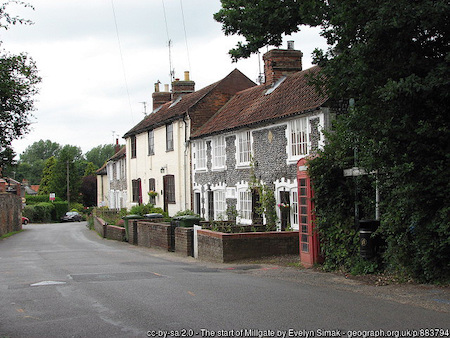
Photo: Millgate, Aylsham
There are currently no reviews for Aylsham. Help the community of movers - leave a review of Aylsham!
Aylsham has a few stores nearby for groceries, including: M&S Aylsham BP, Tesco Aylsham Superstore. There are a few pubs and bars nearby, including: Aylsham Ex Service & Social C, Black Boys Public House, The Feathers Public House, Unicorn Public House. Regarding restaurants and other types of eateries, there are a few nearby, including: Biddys Kitchen, Bread Source, Brunch, Gate of India Restaurant, Juice Bar at Kennedys Health and Fitness, The New Forge, Whistlestop Restaurant. There are a few cafes and coffee shops nearby, including: Aylsham Starbucks, Orange Blossom Cafe. Aylsham has a range of train stations and schools nearby, as shown in the map below.
The property market in Aylsham has had a steep increase over the last few years but slowing growth. Based on data published on 15 November 2023, on average a detached house costs £444,882, which is down -0.4% on last year. A semi-detached house on average costs £286,975 (down -1.6% on last year) , a terraced house £238,569 (down -2.4% on last year) and a flat £152,061. Renting a two bedroom flat will cost you approximately £668 per month. Property prices in Aylsham are similar to the average property prices across Norfolk and are similar when compared to other locations with a similar density in England. When looking at the annual change in property prices in Aylsham, prices have had a greater decrease than the annual average price decrease seen across the Norfolk region.
Property data is based on Broadland level pricing data and is as at September 2023 (publicised 15 November 2023)
Detached and Semi-detached House Trend (£) to September 2023
| County | Avg Detached Price | Annual Change | Avg Semi-Detached Price | Annual Change |
|---|---|---|---|---|
| Rutland | £557,774 | +11.3% | £341,529 | +11.7% |
| Northumberland | £333,743 | +7.3% | £183,403 | +6.1% |
| Lancashire | £326,887 | +4.3% | £195,848 | +3.4% |
| Leicestershire | £432,076 | +3.9% | £262,308 | +3.0% |
| Derbyshire | £340,545 | +3.7% | £209,276 | +2.9% |
| Oxfordshire | £706,629 | +3.5% | £450,305 | +3.5% |
| Merseyside | £340,051 | +3.4% | £214,398 | +2.4% |
| Gloucestershire | £536,963 | +3.4% | £330,457 | +3.4% |
| Nottinghamshire | £334,429 | +2.8% | £206,257 | +2.8% |
| Wiltshire | £521,688 | +2.7% | £328,877 | +3.0% |
| Greater Manchester | £396,806 | +2.7% | £254,125 | +2.3% |
| West Yorkshire | £351,673 | +2.5% | £210,889 | +2.0% |
| West Midlands | £407,684 | +2.2% | £245,250 | +2.4% |
| East Riding of Yorkshire | £326,098 | +2.2% | £203,163 | +2.1% |
| Staffordshire | £364,884 | +2.1% | £221,783 | +2.1% |
| Herefordshire | £434,518 | +2.1% | £276,148 | +2.2% |
| South Yorkshire | £284,409 | +2.0% | £182,869 | +1.9% |
| West Sussex | £686,980 | +1.9% | £441,716 | +2.3% |
| Kent | £619,795 | +1.8% | £386,201 | +1.4% |
| Shropshire | £404,408 | +1.8% | £252,891 | +1.8% |
| Warwickshire | £515,326 | +1.8% | £299,238 | +1.3% |
| Devon | £503,963 | +1.6% | £337,624 | +2.3% |
| North Yorkshire | £422,027 | +1.5% | £265,231 | +1.2% |
| Norfolk | £406,137 | +1.4% | £267,820 | +1.2% |
| North Northamptonshire | £426,370 | +1.3% | £254,947 | +1.2% |
| Buckinghamshire | £853,940 | +1.2% | £460,891 | +1.2% |
| West Northamptonshire | £478,844 | +0.9% | £279,006 | +0.7% |
| Hampshire | £628,455 | +0.6% | £386,140 | +1.0% |
| Lincolnshire | £307,354 | +0.6% | £205,466 | +1.4% |
| Worcestershire | £455,558 | +0.6% | £276,201 | +0.9% |
| Essex | £586,972 | +0.4% | £379,804 | 0.0% |
| Somerset | £465,131 | +0.3% | £296,160 | +0.7% |
| Suffolk | £454,636 | +0.2% | £283,920 | +0.6% |
| East Sussex | £595,763 | +0.1% | £385,074 | +0.4% |
| Cambridgeshire | £486,349 | 0.0% | £330,028 | +0.2% |
| Surrey | £957,680 | -0.2% | £546,201 | +0.7% |
| Isle of Wight | £435,441 | -0.4% | £298,787 | 0.0% |
| Hertfordshire | £939,983 | -0.7% | £542,021 | -0.2% |
| Cornwall | £453,159 | -1.1% | £300,170 | -0.6% |
| Dorset | £528,863 | -1.3% | £348,080 | -0.8% |
Recent property transactions in the area
Listed below are some recent property purchases in the area, to give you an idea of the market. Click on a postcode if you would like to see data on that specific area of Aylsham, or click here to browse the longer list of Aylsham property transactions from 2023.
Aylsham has a few schools nearby to choose from. There are a mix of both primary and secondary schools nearby, including Aylsham High School (Maintained school) which is a secondary school based in Sir Williams Lane, Norwich. Example schools in the area are listed below, with some information on their rating and access criteria.
| School | Type | Latest Rating | Parent View Reviews (if available) | Ofsted Report (if available) | Address |
|---|---|---|---|---|---|
| Bure Valley School Save school | Primary Foundation school - Mixed | 2: Good (2/4/2016) | Ofsted Report Link | Norwich | |
| Aylsham High School Save school | Secondary school Foundation school - Mixed | 2: Good (10/16/2014) | Ofsted Report Link | Norwich | |
| John of Gaunt Infant and Nursery School Save school | Primary Foundation school - Mixed | 3: Requires Improvement (3/4/2020) | Ofsted Report Link | Norwich | |
| St Michael's Church of England VA Primary and Nursery School Save school | Primary Voluntary aided school - Mixed | 3: Requires Improvement (10/30/2019) | Ofsted Report Link | Norwich |
| School | Type |
|---|---|
| Bure Valley School Ofsted report Save school | Primary Latest rating - 2: Good (2/4/2016) |
| Aylsham High School Ofsted report Save school | Secondary school Latest rating - 2: Good (10/16/2014) |
| John of Gaunt Infant and Nursery School Ofsted report Save school | Primary Latest rating - 3: Requires Improvement (3/4/2020) |
| St Michael's Church of England VA Primary and Nursery School Ofsted report Save school | Primary Latest rating - 3: Requires Improvement (10/30/2019) |
| Station | Distance from Aylsham | Commute options |
|---|---|---|
| Salhouse A very quiet station station. Station footfall changed -16% from the previous year. | 13 miles |
- Cambridge (1 change(s) - 106 mins - Greater Anglia) View details - Stratford (London) (1 change(s) - 138 mins - Greater Anglia - £833 monthly fare) View details - London Liverpool Street (1 change(s) - 147 mins - Greater Anglia - £833 monthly fare) View details |
| Sheringham A very quiet station station. Station footfall changed -19% from the previous year. | 13 miles |
- Cambridge (1 change(s) - 143 mins - Greater Anglia) View details - Stratford (London) (1 change(s) - 175 mins - Greater Anglia - £833 monthly fare) View details |
| West Runton A very quiet station station. Station footfall changed -4% from the previous year. | 13 miles |
- Cambridge (1 change(s) - 144 mins - Greater Anglia) View details - Stratford (London) (1 change(s) - 176 mins - Greater Anglia - £833 monthly fare) View details |
| Norwich A relatively busy station. Station footfall changed -4% from the previous year. | 15 miles |
- Cambridge (1 change(s) - 80 mins - Greater Anglia) View details - Stratford (London) (112 mins - Greater Anglia - £833 monthly fare) View details - London Liverpool Street (121 mins - Greater Anglia - £833 monthly fare) View details - Highbury & Islington (1 change(s) - 139 mins - London Overground - £833 monthly fare) View details - Kings Cross (1 change(s) - 147 mins - Govia Thameslink Railway (Great Northern) - £833 monthly fare) View details - London St Pancras (1 change(s) - 159 mins - Thameslink - £833 monthly fare) View details - York (1 change(s) - 169 mins - Grand Central) View details - London Bridge (1 change(s) - 174 mins - Thameslink - £833 monthly fare) View details |
The table below lists ethnicities living in the local authority (Broadland) as per the data published in December 2022. Source: ethnicity-facts-figures.service.gov.uk
| Ethnicity | % of Broadland residents | Benchmark:% of England & Wales residents |
|---|---|---|
| White | 96.3% | 81.7% |
| Asian | 1.4% | 9.3% |
| Mixed | 1.4% | 2.9% |
| Black | 0.5% | 4.0% |
| Other | 0.4% | 2.1% |
The table below lists the types of occupations that residents have, at the Broadland consituency level. Source: commonslibrary.parliament.uk
| Type of occupation | % of residents (over 16 years old) | Rank within England & Wales |
|---|---|---|
| Intermediate occupations | 13.1% | |
| Small employers and own account workers | 14.2% | |
| Higher managerial, administrative and professional occupations | 11.9% | 262 out of 573 |
| Lower managerial, administrative and professional occupations | 21.5% | |
| Lower supervisory and technical occupations | 5.9% | |
| Semi-routine occupations | 12.6% | |
| Routine occupations | 11.1% | |
| Never worked / long-term unemployed | 5.6% | 488 out of 573 |
| Full-time students | 4.1% |
Relative to the UK average, the average broadband download speed in Norfolk is average (46mbps). Aylsham is consistent with this, with average download speeds of 45.6mbps. You can also view really detailed broadband information at the Aylsham level, via data.parliament.uk, here.
| Average speed | 45.6 mbps |
| % households with superfast broadband access | 94.2% |
| % households unable to access decent broadband | 1.3% |
Crime stats were found at the Broadland level:
| Type | Broadland | UK |
|---|---|---|
| Total Crimes (per thousand people) | 46 | 93 |
| Burglaries (per thousand people) | 1 | 5 |
| Public Order Offences (per thousand people) | 5 | 10 |
| Bicycle Thefts (per thousand people) | 0 | 1 |
| Violence Against People (per thousand people) | 22 | 36 |
We use an API provided by Department for Environment Food & Rural Affairs (DEFRA) to identify any live flood warnings to be aware of and we also provide insight into whether flooding could occur from rivers, sea and groundwater within 1km of Aylsham.
There are no live flood warnings in the area, according to our interpretation of the DEFRA API.
The areas in the table below have been identified by the DEFRA API as areas where it is possible for flooding to occur from rivers, sea and in some locations, groundwater. Some of these areas will have measures in place to minimise the risk of flooding and they may be monitored by the Flood Warning Service.
| Area | Cause | Description |
|---|---|---|
| East Anglia | Tud, Wensum, Wendling Beck | The Rivers Tud and Wensum from Fakenham to Costessey, including Wendling Beck |
| East Anglia | Bure, Spixworth Beck | The River Bure, Spixworth Beck and surrounding Becks |
| East Anglia | Bure | The River Bure from Corpusty to Brampton, including Aylsham and Ingworth |
| Name | Property market | Crimes per 1,000 | Schools nearby | Socio Economic |
|---|---|---|---|---|
| Aylsham, Norfolk Affordability: Average Low Crime Low Burglary Rate Happiness High for UK Slowing property market Local M&S Near the coast | Semi-detached: £286,975 Detached: £444,882 | 46 | Primary: 3Secondary: 1 | 11.9% residents in higher managerial positions 5.6% residents long-term unemployed |
| Norwich, Norfolk Affordability: Very affordable Very fast broadband Hot property market Local Waitrose Local John Lewis Local M&S | Semi-detached: £296,619 Detached: £483,838 | 133 | Primary: 26Secondary: 12 | 12.1% residents in higher managerial positions 7.0% residents long-term unemployed |
| Southrepps, Norfolk Affordability: Average Low Crime Low Burglary Rate Slowing property market Near the coast | Semi-detached: £301,917 Detached: £456,525 | 53 | Primary: 2Secondary: | 10.3% residents in higher managerial positions 7.0% residents long-term unemployed |
| Cromer, Norfolk Affordability: Average Low Crime Low Burglary Rate Slowing property market Near the coast | Semi-detached: £301,917 Detached: £456,525 | 53 | Primary: 2Secondary: 2 | 10.3% residents in higher managerial positions 7.0% residents long-term unemployed |
| Erpingham, Norfolk Affordability: Average Low Crime Low Burglary Rate Slowing property market Near the coast | Semi-detached: £301,917 Detached: £456,525 | 53 | Primary: 2Secondary: | 10.3% residents in higher managerial positions 7.0% residents long-term unemployed |
| Horning, Norfolk Affordability: Average Low Crime Low Burglary Rate Slowing property market Near the coast | Semi-detached: £301,917 Detached: £456,525 | 53 | Primary: 2Secondary: | 10.3% residents in higher managerial positions 7.0% residents long-term unemployed |
| Aldborough & Thurgarton, Norfolk Affordability: Average Low Crime Low Burglary Rate Slowing property market Near the coast | Semi-detached: £301,917 Detached: £456,525 | 53 | Primary: 1Secondary: 1 | 10.3% residents in higher managerial positions 7.0% residents long-term unemployed |
| Neatishead, Norfolk Affordability: Average Low Crime Low Burglary Rate Slowing property market Near the coast | Semi-detached: £301,917 Detached: £456,525 | 53 | Primary: 1Secondary: | 10.3% residents in higher managerial positions 7.0% residents long-term unemployed |
| Holt, Norfolk Affordability: Average Low Crime Low Burglary Rate Slowing property market Near the coast | Semi-detached: £301,917 Detached: £456,525 | 53 | Primary: 2Secondary: 1 | 10.3% residents in higher managerial positions 7.0% residents long-term unemployed |
| Mulbarton, Norfolk Affordability: Average Low Crime Low Burglary Rate Happiness High for UK Slowing property market | Semi-detached: £295,451 Detached: £450,308 | 49 | Primary: 1Secondary: | 14.7% residents in higher managerial positions 5.2% residents long-term unemployed |
| Diss, Norfolk Affordability: Average Low Crime Low Burglary Rate Happiness High for UK Slowing property market | Semi-detached: £295,451 Detached: £450,308 | 49 | Primary: 4Secondary: 1 | 14.7% residents in higher managerial positions 5.2% residents long-term unemployed |
| Wroxham, Norfolk Affordability: Average Low Crime Low Burglary Rate Happiness High for UK Slowing property market Near the coast | Semi-detached: £286,975 Detached: £444,882 | 46 | Primary: Secondary: | 11.9% residents in higher managerial positions 5.6% residents long-term unemployed |
| Name | Property | Crimes per 1,000 | Schools nearby |
|---|---|---|---|
| Aylsham, Norfolk Affordability: Average Low Crime Low Burglary Rate Happiness High for UK Slowing property market Local M&S Near the coast | Semi-detached: £286,975 Detached: £444,882 | 46 | Primary: 3Secondary: 1 |
| Norwich, Norfolk Affordability: Very affordable Very fast broadband Hot property market Local Waitrose Local John Lewis Local M&S | Semi-detached: £296,619 Detached: £483,838 | 133 | Primary: 26Secondary: 12 |
| Southrepps, Norfolk Affordability: Average Low Crime Low Burglary Rate Slowing property market Near the coast | Semi-detached: £301,917 Detached: £456,525 | 53 | Primary: 2Secondary: |
| Cromer, Norfolk Affordability: Average Low Crime Low Burglary Rate Slowing property market Near the coast | Semi-detached: £301,917 Detached: £456,525 | 53 | Primary: 2Secondary: 2 |
| Erpingham, Norfolk Affordability: Average Low Crime Low Burglary Rate Slowing property market Near the coast | Semi-detached: £301,917 Detached: £456,525 | 53 | Primary: 2Secondary: |
| Horning, Norfolk Affordability: Average Low Crime Low Burglary Rate Slowing property market Near the coast | Semi-detached: £301,917 Detached: £456,525 | 53 | Primary: 2Secondary: |
| Aldborough & Thurgarton, Norfolk Affordability: Average Low Crime Low Burglary Rate Slowing property market Near the coast | Semi-detached: £301,917 Detached: £456,525 | 53 | Primary: 1Secondary: 1 |
| Neatishead, Norfolk Affordability: Average Low Crime Low Burglary Rate Slowing property market Near the coast | Semi-detached: £301,917 Detached: £456,525 | 53 | Primary: 1Secondary: |
| Holt, Norfolk Affordability: Average Low Crime Low Burglary Rate Slowing property market Near the coast | Semi-detached: £301,917 Detached: £456,525 | 53 | Primary: 2Secondary: 1 |
| Mulbarton, Norfolk Affordability: Average Low Crime Low Burglary Rate Happiness High for UK Slowing property market | Semi-detached: £295,451 Detached: £450,308 | 49 | Primary: 1Secondary: |
| Diss, Norfolk Affordability: Average Low Crime Low Burglary Rate Happiness High for UK Slowing property market | Semi-detached: £295,451 Detached: £450,308 | 49 | Primary: 4Secondary: 1 |
| Wroxham, Norfolk Affordability: Average Low Crime Low Burglary Rate Happiness High for UK Slowing property market Near the coast | Semi-detached: £286,975 Detached: £444,882 | 46 | Primary: Secondary: |
Do you live in Aylsham or have visited before? A short review would really help the community surface the best places to live. Thank you!
Other resources to help with your research
Other locations nearby:
|
Explore Aylsham in more detail: More locations in Norfolk | School map explorer | Recent house purchases in area |